Forces Majeures
“Daddy, what’s the biggest ever tidal wave?”. A pretty standard question from an inquisitive 8 year old, and probably sandwiched somewhere between “What is the most poisonous spider?” and “Who would win a fight between Tyrannosaurus Rex and a Megalodon?”. As smart as I like to think I am, I didn’t have the answer to this one at my fingertips so we reverted to the world wide web.
“July 1958, Lituya Bay in Alaska. A 7.8 magnitude earthquake caused 80 million tonnes of rock and ice to drop from a mountainside into a narrow fjord. The resulting mega-tsunami reached 524 metres high. That’s a wall of water higher than the Empire State Building.”
So big in fact, it’s hard to imagine what that would look like. I live on the sunny side of a valley, just 100 metres above Bourg St. Maurice. Bourg itself sits at 850 metres altitude. If I look 524 metres up the opposite side that’s about two thirds of the way up the funicular railway to Les Arcs, around the Les Granges mid-station. A wall of water that high rushing towards me is an utterly terrifying thought and brings to mind Tignes dam, a 75 year old concrete barrier holding back 230 million cubic metres of water, just 20 km up the valley from us.
This question came from my son some ten years ago. It was an interesting subject to look into but happened sixty years ago and in a remote part of Alaska. Something from the history books. Then, this year, I came across a news report about a much more recent mega-tsunami.
In August 2025, again in a remote part of Alaska, 160 million tonnes of rock fell from the mountainside into the Tracy Arm Fjord, creating a tsunami 482 metres tall – making it the second largest ever recorded. The location was so remote it was barely noticed at the time. Only through later scientific analysis did the scale became clear. Although distant, this is an area frequented during the day by cruise ships. As luck would have it, the landslide occurred in the early hours of the morning so no one was killed.
The big difference this time was the cause – not an earthquake but a melting glacier. The South Sawyer Glacier had receded to the point that a section of rock that was previously being held up, released in one go.
We know glaciers grow and shrink. In geologically recent terms, they peaked around 25,000 years ago during the Last Ice Age when they covered most of Europe. Since that ended 12,000 years ago they have advanced and retreated many times but to a much smaller extent. The Little Ice Age, which reached it’s zenith in 1850, saw glaciers grow again before the current trend of decline really kicked in, coinciding with the industrial revolution. There was a brief period of cooling between 1950 and 1980 but since the 90’s glacial retreat has accelerated world wide.
We see abundant evidence of this in the Alps and of course this summer has been more significant than most, with numerous heatwaves compounding the shrinkage. Most people will have come across ‘before and after’ photos of local glaciers, comparing their extent in the 80’s and 90’s to current day.
Locally this is most obvious in Tignes and Val d’Isere, where glacier skiing used to be extensive and virtually year round. This year Val d’sere glacier only opened for a couple of weeks in June and Tignes closed ahead of schedule on the 16th July. On the 15th August, Stelvio in Italy closed its summer ski area due to persistent hot temperatures. This landmark closure meant 2026 was the first year in European ski history where no lift accessed ski areas were open after mid-August.
It’s not only skiing that has been effected by the exceptionally hot summer. In August, the mayor of St. Gervais ordered the temporary closure of the Gouter and Tete Rousse mountain refuges. These are both situated on the least technical and therefore, most popular, route for climbing Mont Blanc. They sit either side of the Grand Couloir, considered to be the most dangerous part of the ascent. Two climbers died here in July after being hit by falling rocks.
During daytime in the summer months, the sun warms the slopes above, causing ice to melt, releasing rocks which tumble down the couloir right across the path between these two mountain huts. The heatwave and drought conditions of this summer have resulted in a large increase in this activity, prompting the recent closure.
High altitude thawing has caused significant geological activity right across the Alps over recent years. In May 2025, 10 million cubic metres of rock and ice slid from the Blatten glacier in Switzerland, burying most of the village below. Fortunately the incident had been predicted and a complete evacuation had been ordered ten days previously. Throughout the preceeding spring, landslides from the surrounding peaks had built up on the glacier to the point that the pile of debris exceeded 80 metres in depth. This extra weight accelerated the glaciers descent towards the valley to the point it was moving at a rate of 10 metres per day. Something had to give and on the 28th of May it did in spectacular fashion.
It is difficult to directly attribute climate change and melting permafrost to such incidents but a local glaciologist Wilfried Haeberli, pointed to the increase in landslides in that area. “Between 1900 and 1980, four landslides were recorded, roughly one every twenty years. Since 2000, eight have occurred, averaging one every three years” The decline in permafrost correlates with this increase.
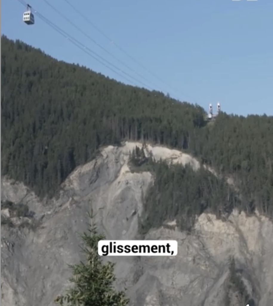
Of course, this kind of geological activity is not solely down to increased temperatures. Mountains get pushed up through the movement of tectonic plates and inevitably, over time they crumble and slough back down towards the valley. It’s a constant cycle. Just ask the residents of Peisey-Nancroix. This village in Les Arcs sits under the Vanoise Express cable car, linking Les Arcs with La Plagne. If you’ve been across it recently you will have noticed the angry grey scar right under the Montchavin-Les Coches side of the cables.
This part of the mountain is undergoing rapid erosion. Residents regularly hear the crack of boulders bouncing down the steep slope towards the river and this summer has been worse than ever, with rockfalls occurring on a daily basis. It looks vastly different to how it did just ten years ago. You can clearly see the remnants of an old footpath that, until recently, crossed this slope. If a big slide occurred here the real concern would be blocking the river below, leading to a build up of water then sudden flood which could cause serious damage to the village down river. And the grey scar is creeping slowly towards the Vanoise lift station.
https://www.ledauphine.com/videos/eboulements-en-savoie-le-vanoise-express-est-il-menace-3k0flzr
Ever driven up the Val d’Arly? If you have you probably got lucky. The lower part of this road has been closed for around a third of the twenty five years Cool Bus has been operating. The steep sided gorge provides a spectacular short cut from Ugine in Savioie, through to Megeve, St Gervais and ultimately Chamonix in Haute Savoie. Unfortunately it is also spectacularly unstable.
Every couple of years, huge slabs of rock trundle down the mountainside and drop onto the carriageway below. The road will close for 6-12 months to make everything secure, put up some safety netting, maybe build a few more concrete walls then open up again. Until the next time. You hear talk of it being the most expensive road in France to maintain and I can believe that. Right now it’s open and it is a beautiful drive so why not roll the dice?
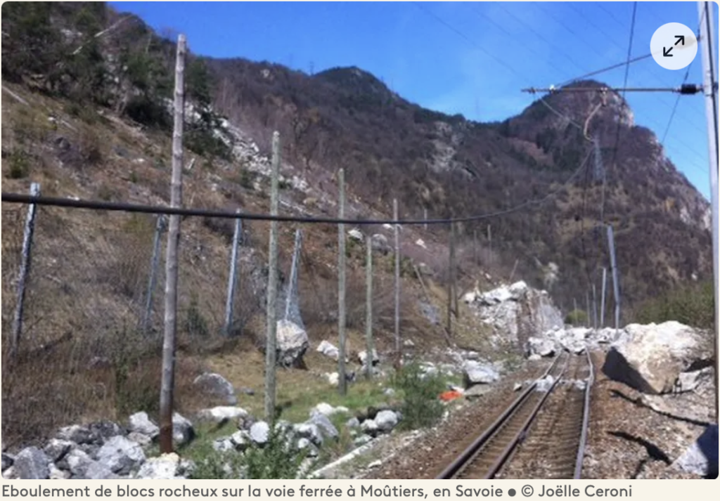
If you’ve driven through the Tarentaise valley over the last ten years you will have used the ‘new’ bypass near Pombliere. This short section of dual carriageway takes you along the left bank of the Isere. It was a very expensive section of road to build but deemed necessary due to concerns over the stability of the mountain on the right bank. Cast your eyes over to that side and you’ll see some commercial buildings that have a few unplanned holes in them due to rockfall. They didn’t go so far as to redirect the train though and a landslide in April 2015 damaged the tracks meaning train travel past Moutiers was out of the question for several weeks.
During the building stage of this dual carriageway a rockfall also partially crushed a digger on the left bank. It was deemed too dangerous to move so it became a local landmark for several years. The authorities obviously decided this was not a great advert and covered it over with some netting but it was easy enough to spot of you knew where to look.
Torrential rain in the summer has also played its part. Bourg St. Maurice was once very famous for its canoe slalom course, hosting rounds of the World Cup and a World Championships in the eighties and nineties. The course from those days bears little resemblance to the current set of rapids. On two separate occasions, huge storms and the resulting mudslides have shifted the boulders that made up the falls and eddies of the slalom course, requiring a revamp. The current iteration is actually steeper and more extreme than the eighties version. The most recent of these storms in 2019 also caused a stage of Tour de France to be cut short for safety reasons, when a mudslide covered the road up to Tignes.
From a more selfish point of view, all this geological activity causes us the most drama when it affects the roads and traffic. We are lucky in the Tarentaise valley, to be surrounded by some of the biggest ski resorts in the world – Les Arcs, La Plagne, Tignes, Val d’Isere, Meribel, Courchevel, we literally have limitless terrain right on our doorstep. It makes an ideal spot to set up a transfer company with the large volume of tourists coming to the area.
We are also unlucky enough to have some of the biggest ski resorts in the world in our valley which are accessed via just one dual carriageway from Albertville. The huge volume of tourists flocking to this area means we have to deal with significant traffic delays virtually every Saturday of the winter season. As such it makes a terrible location to set up a transfer company!
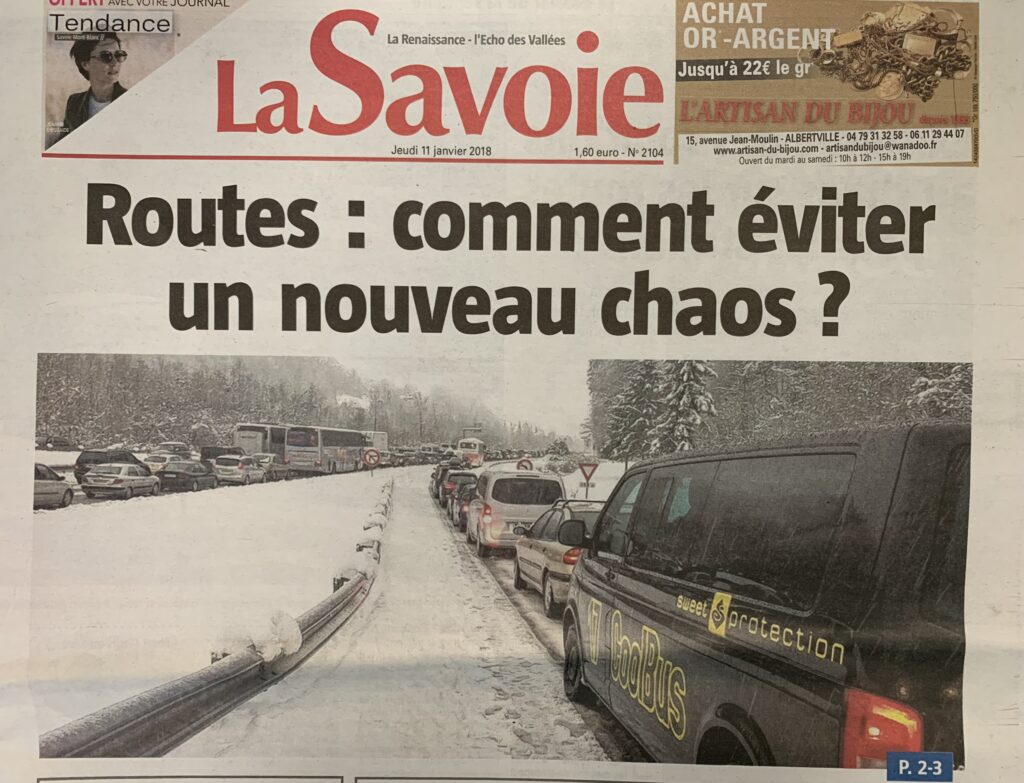
Fortunately, the traffic jams are, for the most part, reasonably predictable. We know which weekends will be the worst and roughly at what times the traffic will peak in either direction. This starts to fall apart however, when the weather stops playing ball. Heavy snowfall combined with peak traffic can cause total mayhem. Ask any seasoned transfer driver what they were doing on Saturday the 27th December 2014 and see a haunted look spread across their face.
New Years week is literally the busiest of the entire season in terms of filled beds in resort. In 2014 we had experienced an unusually dry Christmas week. Imagine the looks of sheer disgust on the faces of tourists that had spent a week skiing on mostly artificial snow only to wake up on transfer day to discover a 40cm+ of fresh all the way down to the valley floor. To compound this insult many of them spent the next 10+ hours sat in stationary traffic in what went into the history books as one of the worst transfer days in living memory.
https://www.bbc.co.uk/news/world-europe-30613481
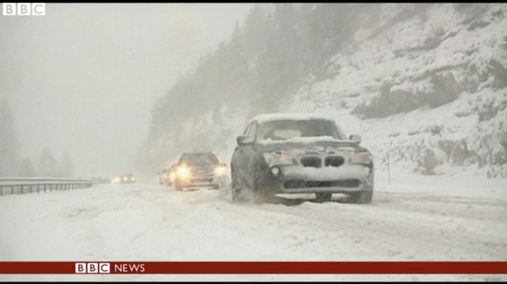
We had drivers queuing for 4 hours just to drive from Tignes Val Claret to the dam (around 4km). Many took 12 hours just to get as far as Moutiers. Any hope of catching flights were dashed long before vehicles even made it to the valley floor. Many drivers finally arrived at Geneva, Lyon and Chambery airports in the late evening and then took refuge with their inbound clients in temporary shelters set up by the local authorities, along with 15,000 other stranded tourists. It was catastrophic.
While the extent of delays in cases like these are hard to predict, at least you can see from the weather forecast that something drastic is looming on the horizon. With landslides this is not the case. They strike with no warning and frequently at the worst times.
On the night of the 27th February, 2015, a 50 tonne boulder came to rest on the RD117, blocking the main access road between Moutiers and the resorts of Val Thorens, Les Menuires and St. Martin-de-Belleville. This was a Friday night, right in the middle of the French holidays. A lump of rock that size, and it was nearly 6 metres high, can’t simply be pushed to the side of the road. Shifting it required explosives and took a whole week to achieve.
The Belleville valley makes up one third of the largest connected ski area in the world – Les Trois Vallees. This one valley alone welcomes 600,000 tourists each winter. You can imagine the chaos when the main access road is blocked on one of the busiest transfer days of the season. The saving grace was that the rock fell onto the road below the junction to a much smaller access road. As such it was still possible to get in and out of the valley but this road is extremely narrow and not suitable for a large volume of traffic or for coaches.
The best solution was to open it to traffic leaving the valley on the Saturday morning and then to traffic arriving only in the afternoon. The downside was what to do with all the vehicles arriving on Saturday morning that had to wait many hours until they could tackle the climb up to resort. The knock on affect was traffic chaos along the N90 dual carriageway, affecting everyone arriving into the Tarentaise across the whole weekend. Another one we try to forget!
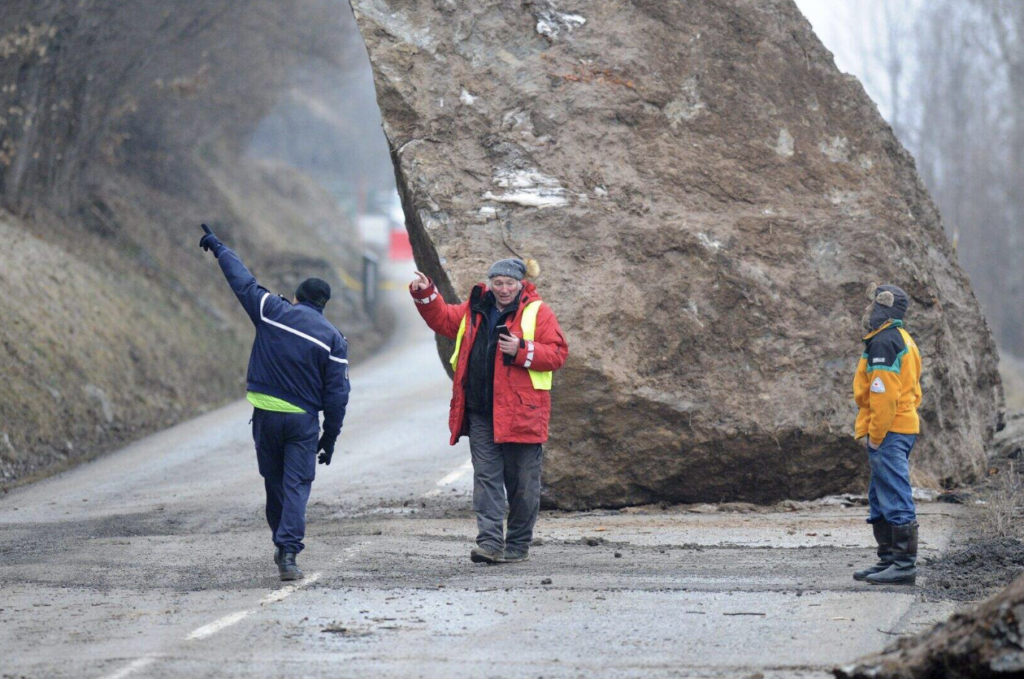
Can it get any worse? Unfortunately yes. On the 1st February 2025 at 10:45 in the morning, three 150 tonne boulders smashed down the mountainside onto the N90 dual carriageway between Moutiers and Albertville. This time it was a Saturday morning. The west bound carriageway of this section of road was fully charged with traffic leaving the valley at the time but fortunately passes through a tunnel. Only the east bound section was affected and traffic was relatively light at the time with only one vehicle hit and light injuries to one person. Had it occurred four to five hours later, the road would have been saturated with vehicles and there would surely have been multiple casualties.
In this case access into the entire Tarentaise Valley was blocked. That’s tourists arriving to three of the five biggest resorts in the world – around 30,000 vehicles. The only solution was to switch the two lane west bound tunnel to allow a single lane of traffic in each direction. This took several hours to set up, by which time, queues were already huge but went biblical through the course of the afternoon as 60,000 vehicles attempted to pass each other through this narrow pinch point.
Scenes were very similar to those of December 2014 with stationary traffic between Moutiers and Albertville, 12 hour+ journey times and emergency shelters in force. Seasoned transfer drivers found their PTSD kicking in from eleven years previous.
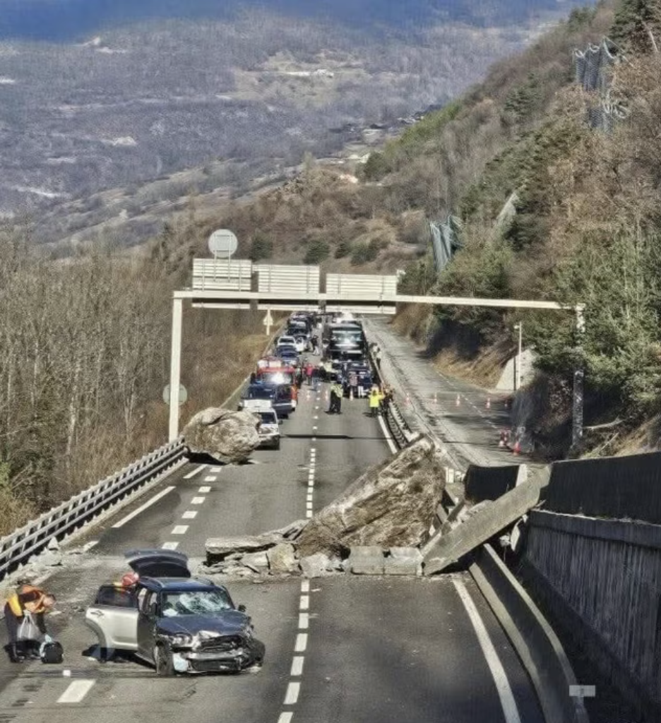
As mentioned, it was extremely fortunate timing that meant no one was killed in this incident but boulders don’t need to weigh 150 tonnes to cause casualties.
There is a section of road we drive through daily on our way to Geneva, between Albertville and Annecy, with a lay-by that acts as a convenient spot for truckers to park up for a break. One enterprising young lady saw a business opportunity here and set up shop. She became a familiar landmark, sat on her chair, gesturing at passing traffic. Our drivers would often give her a friendly wave as they passed and she was soon given the nickname Lay-by Lil.
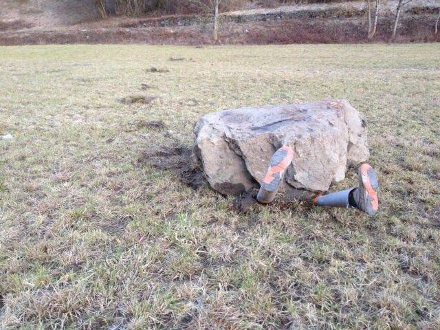
Then one fateful morning in February 2017, our first driver to pass through this area saw a boulder which had fallen down from the nearby hillside, bounced several times across a field and come to rest. He could see two legs poking out from one side. He immediately pulled over and then ran to the scene to see if anything could be done to save her.
On a closer inspection it became clear that some joker had actually just shoved two broom handles under the rock and then dressed them with leggings and a pair of boots. Lay-by Lil lives on, to the joy of truckers of the Savoie!
Looking for a more sustainable way to travel to the French Alps for your holidays? Consider taking the train. France’s high speed TGV rail network runs entirely on renewable and nuclear energy giving it the lowest carbon footprint of any high speed railway system in the world. If rail travel simply doesn’t work for you in terms of the connectivity from your local area and flying is the only feasible option, choose a low carbon method to get from the airport to your chosen resort. Cool Bus, with it’s fleet of electric vehicles, provides airport shuttles with the lowest carbon footprint of any comparable local supplier.
